Configuring your IoT device
GNSS and APNT configuration.
Currently the primary configuration function of the app is focused on GNSS and APNT positioning functionality.
All settings can also be made within the user.cfg file or remotely via Cloudloop device manager.
NOTE: APNT is not fitted as standard. Only available on the APNT version of the RockBLOCK PRO
Full device configuration details available here:
![]() | ![]() | ![]() |
|---|---|---|
![]() | ![]() | ![]() |
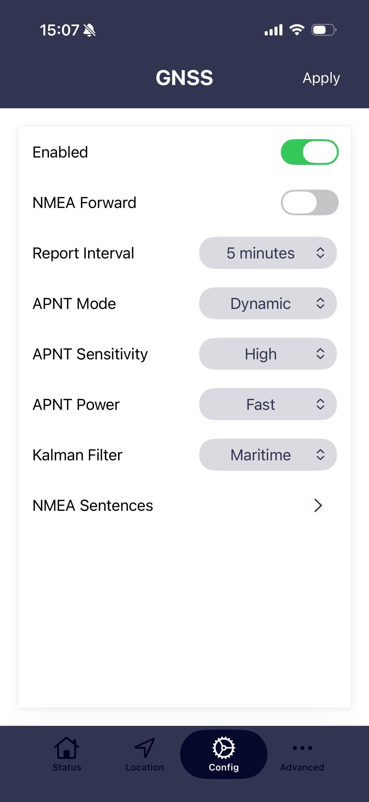
NOTE that for settings to take effect the APPLY button in the top right needs to be pressed.
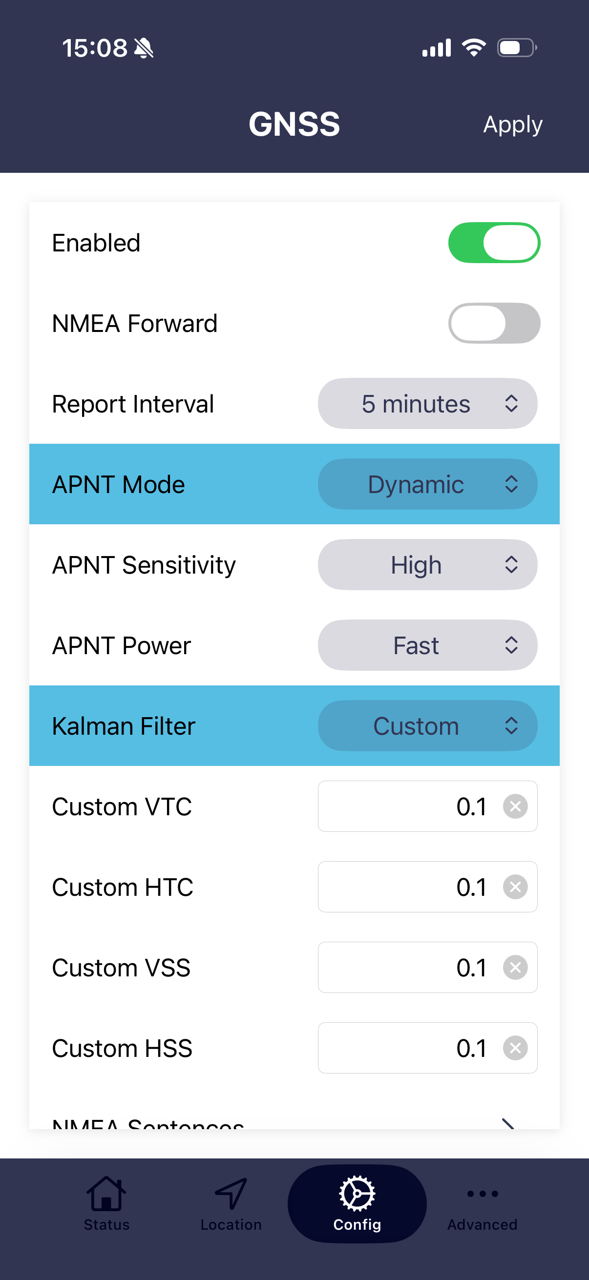
Enabled
When enabled the PRO-APNT will begin reporting both APNT and GNSS positions to Cloudloop with the set interval.
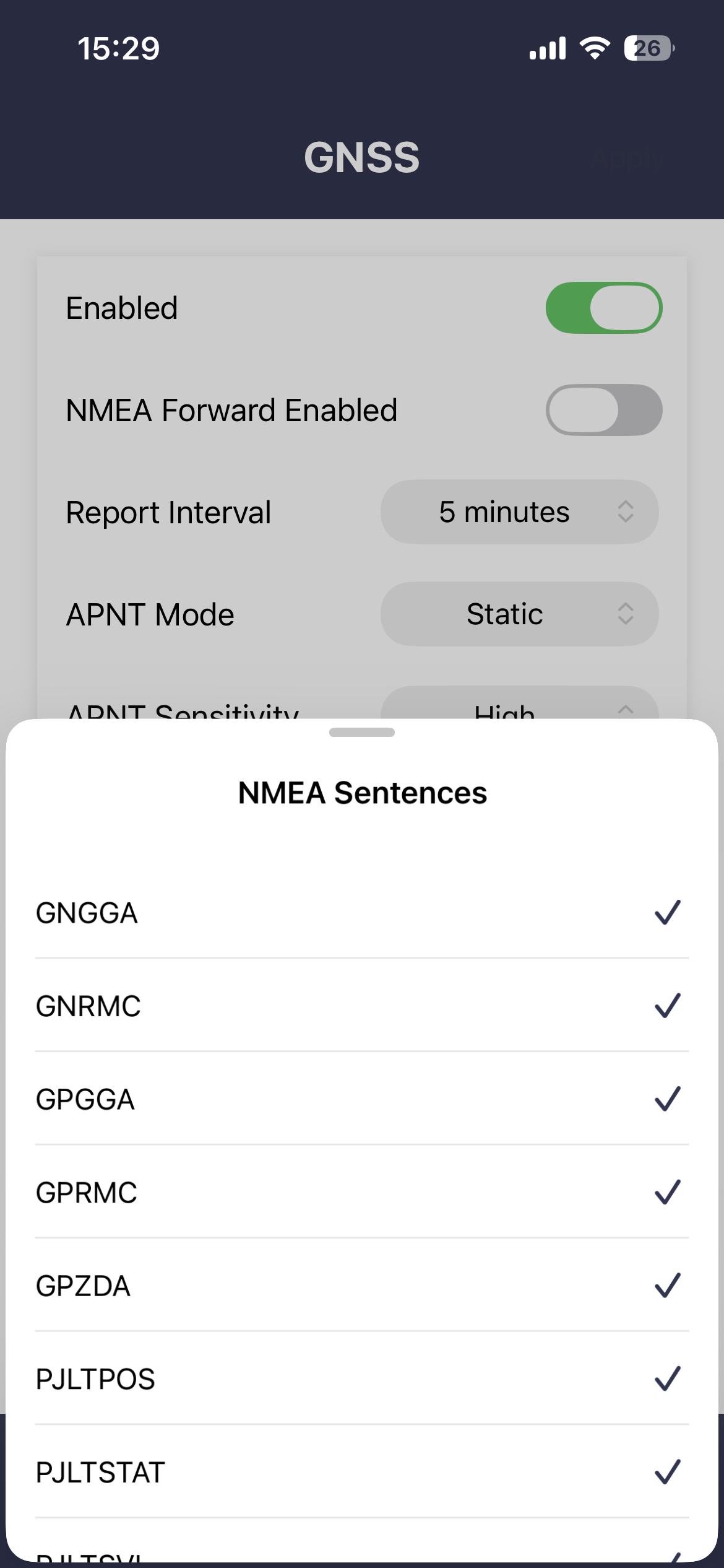
NMEA forward enabled
When enabled the selected sentences will be streamed on the serial interface. Most sentences are streamed every second or when available. PJLTSVI is only streamed on receipt of an APNT burst.
Report interval
Set's the inteval between each APNT and GNSS position reports to Cloudloop. The setting will correct to the nearest whole denomination of time. i.e. for 1 hour it will be at the top of the hour etc.
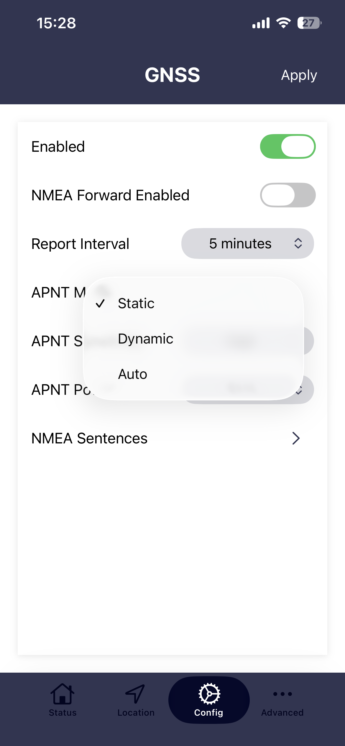
APNT modes
- Static. The device assumes that it remains in a fixed position. Kalman filter pre-sets or custom settings are not applied. Over time, Static mode will arrive at the most accurate time and position.
- Dynamic. Applies the Kalman filter pre-set or custom settings to better track a moving object.
- Auto. Auto mode uses GNSS source to determine if receiver is moving to automatically switch between static and dynamic mode.
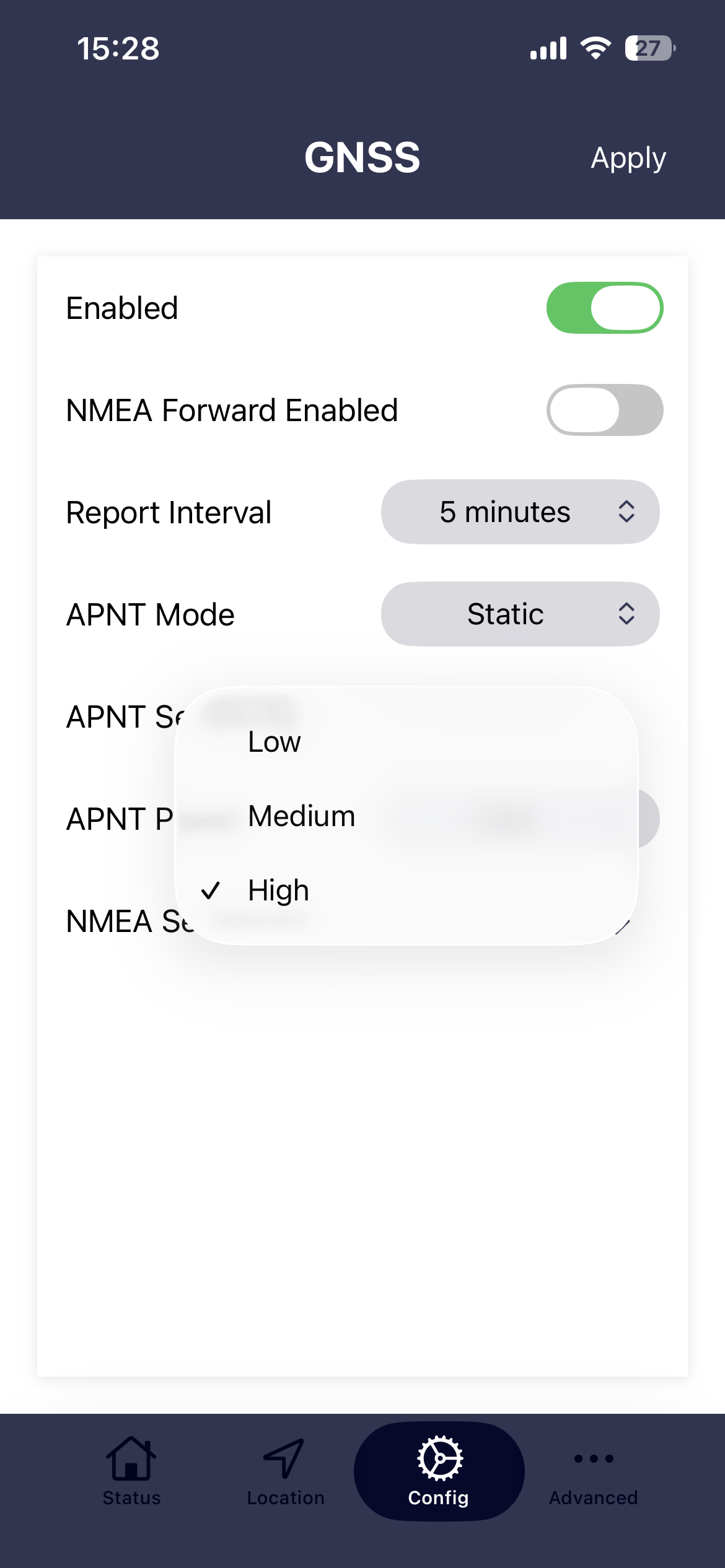
APNT sensitivity
This setting controls the gain of the receiver pre-amplifier. High sensitivity will give the best results when indoors or in areas with a restricted view of the sky. However, when a very high rate of Iridium STL® bursts are available there can be advantages in lowering the sensitivity as this helps to reject bursts that have a degraded measurement quality. This will improve timing and positioning accuracy.
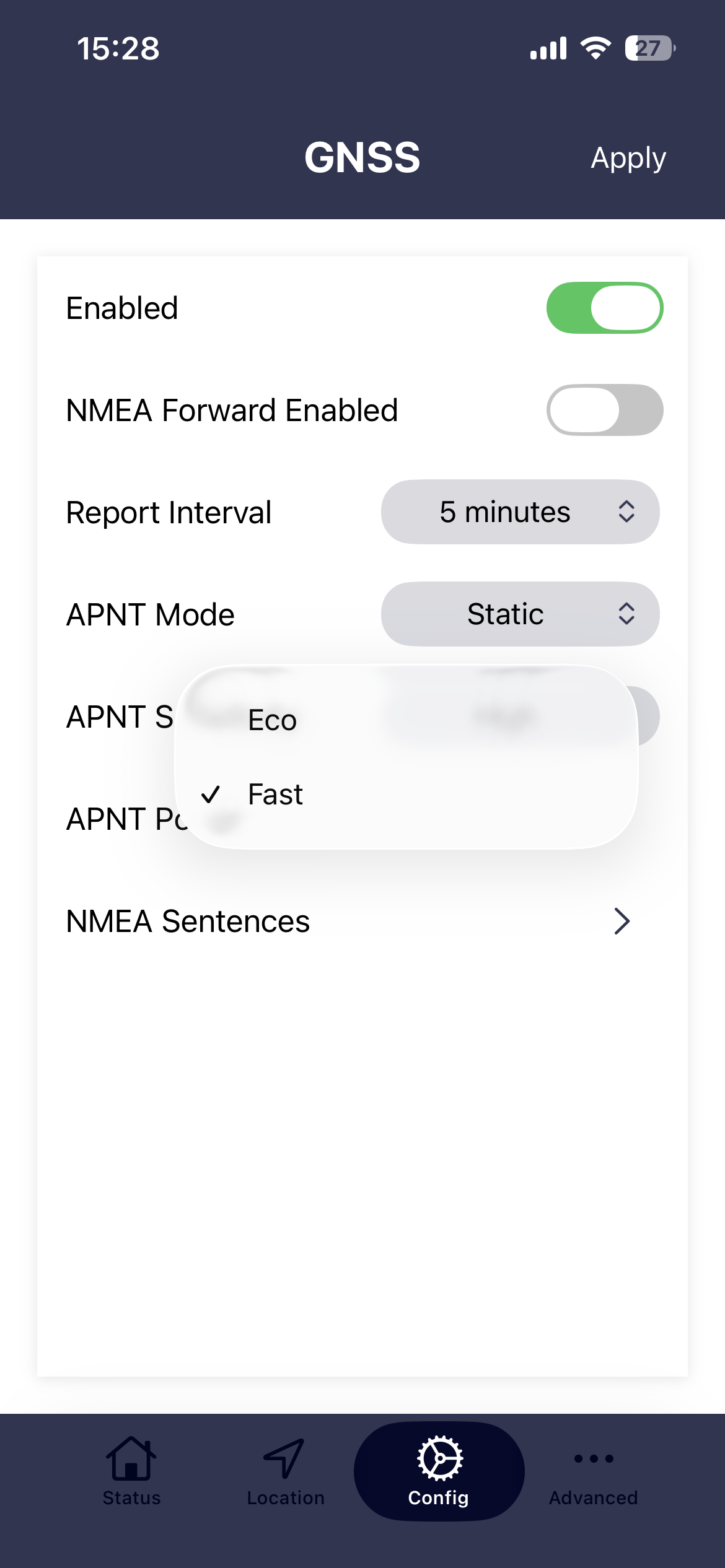
APNT power(saving)
- Fast This setting will give the best performance as ALL of the APNT modules power saving features will be turned off.
- Eco Enables all of the APNT modules power saving features. Power saving will be between 300mW to 500mW. Note that one of the power saving features is to turn OFF the GNSS receiver so for any application that uses GNSS (i.e. if the APNT mode is set to Auto, the APNT power(saving) must be set to off)
APNT Kalman profiles
- Custom. Allows the user to set Kalman filter settings to better suit a particular application.
- Maritime. These settings are recommended for larger vessels.
- Walking. Tracking personnel on foot.
- Driving. Vehicle based applications in relatively flat terrain.
Custom Kalman Filter settings
| Parameter | Description | |
|---|---|---|
| VTC | Vertical Time Constant | Time constant over which the vertical velocity vector is likely to change (seconds) |
| HTC | Horizontal Time Constant | Time constant over which the horizontal velocity vector is likely to change (seconds) |
| VSS | Vertical Steady State | Standard deviation of vertical velocity vector (meters/second, 1-sigma) |
| HSS | Horizontal Steady State | Standard deviation of horizontal velocity vector (meters/second, 1-sigma) |
These parameters affect how the PRO-APNT internal Kalman Filter estimates dynamic position in the absence of bursts or aiding inputs.
The time constant represents the PRESUMED rate at which the velocity vector is liable to change.
The steady state is the PRESUMED standard deviation of the velocity PDF (probability distribution function), in the axis or plane of interest.
A highly-dynamic, fast-moving object would necessitate a large steady state and a small time constant.
A slow-moving object that changes direction and speed only rarely would necessitate a small steady state and a large time constant.
For reference the Kalman Filter profiles are as follows:
| Pre-set | VTC [s] | HTC [s] | VSS [m/s] | HSS [m/s] |
|---|---|---|---|---|
| Maritime | 5 | 300 | 0.1 | 15 |
| Walking | 5 | 300 | 0.1 | 5 |
| Driving | 30 | 10 | 0.1 | 10 |
NMEA Sentences
- The user is able to tailor the NMEA stream to provide the sentences required by their application.
- GNGGA and GNRMC are GNSS positioned provided by the GNSS decoder with the APNT module.
- GPGGA, GPRMC and GPZDA are Iridium APNT related position/time data reporting in the GPS sentence format. NOT GNSS
- All PJLT prefixes relate to Iridium APNT position/time data. Further details on sentence structure below.
- NOTE: When PJLTSTAT is selected the NMEA stream will also contain PJLTVEL.
$PJLTPOS,v,ssssssssss,f,ll.llllllll,yyy.yyyyyyyy,aaa.aa,xxxxxxxxx,yyyyyyyyy,zzzzzzzzz,uu.uuuu,uu.uuuu,uu.uuuu,uu.uuuu,uu.uuuu,uu.uuuu,b.b,s.s,p,g*[checksum]
- v is the message version
- ssssssssss is the current time with "format of time" below
- f is the format of time: 0 = GPS time and – 1 = Unix time
- ll.llllllll is the latitude in signed decimal degree
- yyy.yyyyyyyy is the longitude in signed decimal degree
- aaa.aa is the antenna altitude above/below GPS height in meters when receiving STL signals and MSL height when operating from the GNSS receiver
- xxxxxxxxx is the position in ECEF-X axis, in meter
- yyyyyyyyy is the position in ECEF-Y axis, in meter
- zzzzzzzzz is the position in ECEF-Z axis, in meter
- uu.uuuu are the uncertainty represented as local level covariance for EE, NN, UU, EN, EU, and NU, respectively
- b.b is the age of position in seconds since last burst
- s.s is the age of position in seconds since last sensor update
- p is the position figure of merit (PFOM) of current solution
- g is the current geo-location model configured 1 = STATIC.
$PJLTSTAT,v,ssssssssss,b,s*[checksum]
- v is the message version
- ssssssssss is the GPS time (number of seconds since GPS epoch in 1980)
- b is the number of received bursts in last 60 seconds (bursts per minute, or BPM)
- s is the number of received strong (processed) bursts in last 60 second
$PJLTSVI,v,ssssss.ssssss,wwww,ii,cc.c,aaa.a,ee.e,xxxxxxxxx.x,yyyyyyyyy.y,zzzzzzzzz.z,xxxxxxxxx.x,yyyyyyyyy.y,zzzzzzzzz.z,ddddd.d,rrrrrrrrrrrrrrr.r,,,tttttt.ttttttttt,0xVV*hh
- v Version of reported PJLTSVI message
- ssssss.ssssss GPS TOW (TOT) GPS Time of Week representing the time of transmission in seconds. Time is referenced to the middle of the burst waveform (a burst is 20.32 milliseconds long, so the middle occurs 10.16 milliseconds from the start) Note: Although GPS TOW is truncated to 1 us precision, all SVI data is derived from full precision TOT.
- wwww GPS week number (weeks) associated with GPS TOW (TOT)
- ii SV ID Satelles satellite identification number for the current satellite
- cc.c C/No Carrier to noise density ratio of current burst (dB-Hz). Typical values for processed bursts range from 40 dB-Hz to over 80 dB-Hz
- aaa.a Azimuth (degrees) to the current satellite viewed from the receive antenna based on current best estimate of position [empty when internal position state unknown]
- ee.e Elevation (degrees) to the current satellite viewed from the receive antenna based on current best estimate of position [empty when internal position state unknown]
- xxxxxxxxx.x Current satellite’s position in ECEF-x axis (meters) at the time of transmission
- yyyyyyyyy.y Current satellite’s position in ECEF-y axis (meters) at the time of transmission
- zzzzzzzzz.z Current satellite’s position in ECEF-z axis (meters) at the time of transmission
- xxxxxxxxx.x Current satellite’s velocity in ECEF-x axis (meters/second) at the time of transmission
- yyyyyyyyy.y Current satellite’s velocity in ECEF-y axis (meters/second) at the time of transmission
- zzzzzzzzz.z Current satellite’s velocity in ECEF-z axis (meters/second) at the time of transmission
- ddddd.d Doppler (Hz) for the current burst. Polarity corresponding to range rate (i.e. negative for approaching SV, positive for receding SV).
- rrrrrrrrrrrrrrr.r Pseudorange (meters) for current satellite maximum value of 1 light-week ~1.8e14
- Tttttt.ttttttttt GPS TOW (TOA) GPS Time of Week representing the time of arrival in seconds. Time is referenced to the middle of the burst waveform (a burst is 20.32 milliseconds long, so the middle occurs 10.16 milliseconds from the start)Note: Time of arrival in GPS time is empty until internal position state is known.
- VV Validity Flags Hexadecimal value representing multiple validity flags for data contained within the current message. Valid satellite Pseudorange data VV |= 0x1; Valid satellite Position data VV |= 0x2;
$PJLTVEL,v,iiiiiiiiii,e.eeeeee,n.nnnnnn,u.uuuuuu,ssssssssss*[checksum]
- v is the message version,
- iiiiiiiiii is the serial number for the APNT receiver
- e.eeeeee is the velocity in east direction, in m/s
- n.nnnnnn is the velocity in north direction, in m/s,
- u.uuuuuu is the velocity in up direction, in m/s,
- ssssssssss is the GPS time (number of seconds since GPS epoch in 1980).


